A few years ago I decided to buy a four wheel drive, but I couldn’t see myself roaring about the streets of my suburb in a thumping big one. So I bought a little version that allowed for the fact that although I live and work in the city, my heart yearns for those off-the-beaten-track adventures that only a low-range, high-clearance 4WD can deliver. Our Suzuki Jimny took us on such an adventure recently when we turned off the Gwydir Highway just out of Grafton and onto the Old Glen Innes Road for a day trip back in time. I mention this because although most of this trip can be done in 2WD – one side adventure can’t.
The 180km road opened in 1867, following tracks carved out by bullock drays in the 1840s. The road was the only link between the towns of the New England and the NSW coast for almost 100 years. Cobb and Co ran what must have been a tortuous mail and passenger service between Glen Innes and Grafton which took three gruelling days. Timber getters and farming types also used this route, and when gold was found, short-lived settlements sprang up. The road passes beside spectacular wild rivers (the Nyboida, Boyd, Guy Fawkes, and Mann) and through breathtaking scenery.

WHAT WE LOVED…
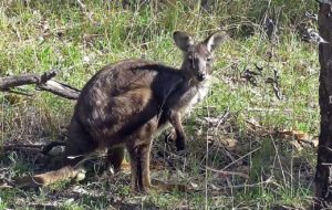
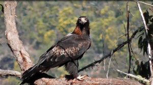
The remoteness of it all for one thing. The feeling of being on the road less travelled – passing just a handful of other vehicles over the whole day. It was very easy to let your imagination take you back to the days of Cobb and Co and the sound of the bullockies rumbling past and the cracking of whips. There’s nothing more deliciously melancholy than faded townships that have seen so much life and so much better days. The history and the mystery were very compelling. The natural beauty of the landscape was superb – and the wildlife abundant. Charming rural scenes around every corner.
WHAT WE SAW…
A bridge too far
Buccarumbi is where Old Glen Innes Road crosses the Nymboida River by a low level concrete bridge. There’s a riverside camp site at this spot (with flushing toilets – yay!) Ideal for a picnic or rest stop. Buccarumbi was once a stopover for weary Cobb and Co Coach travellers and loggers and there were two pubs there to cater for them. Today there’s no village – but if you wander down to the crossing you can still see what remains of the high level bridge which once spanned the river. Huge cement-filled steel pylons tumbled about all over the place. This former substantial bridge was destroyed by a flood in March 1946 when the surging Nymboida reached a record height of 16m. Must have been a doozie of a flood! Very picturesque spot though.

Ghost town
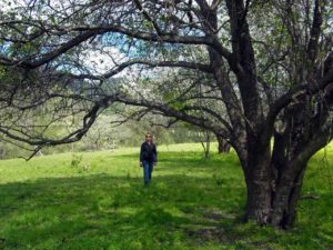
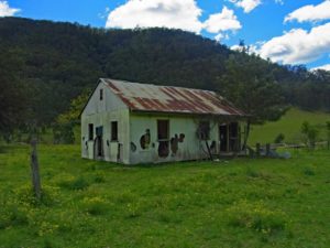
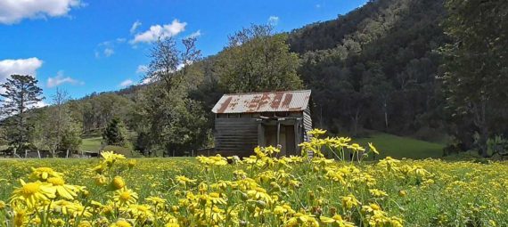
As you round the bend into Dalmorton, the ramshackle remains of a once busy gold-rush township are visible against the backdrop of the surrounding hills. A few decaying abandoned buildings hang on. The 1930s wooden butcher’s shop, an old house built in the 1950s with it’s tin roof peeling away and flapping mournfully in the wind. We take a wander through an old orchard of fruit trees that were in blossom on the day we went through – mute testament to lives long gone. Apples, citrus, and an ancient mulberry tree. Signs at the site say Dalmorton went from tiny village to bustling gold town overnight. The prosperity continued until the gold ran out. Then it became a timber town, then a rural backwater, and then nothing but a stop for curious day trippers.
Tunnel vision
About 8km from Dalmorton there’s an historic tunnel bored through solid rock. Apparently the handiwork of civilian labourers in the 1800s when they came to an impassible obstacle to the progress of the road. Narrow and with a clearance of just 3.3m – it’s just big enough for the stage coach to go through. Old graffiti dating back to that time is high on the roof – but has been joined by new – and somehow less appealing – modern graffiti. It’s rather an amazing feat when you realise the whole thing was hand cut.

WWI tragedy
Not too much further on you come to the locality of Newton Boyd – these days just a collection of farm houses. Beside the road is a concrete and stone cenotaph bearing the names and ranks of 30 young men from local farms who enlisted in WWI. Only one of the 30 survived the war – a member of the Lacey family. Tragically, he too was later accidentally killed in a rock slide. The inscriptions show that five men with the surname Meehan were among the fallen – more than likely from the same family. It’s a sad and thought provoking place.

Outlaw lookout
We continued on toward Glen Innes, eventually coming to the turn off to Tommy’s Rock Lookout in the Mann River Nature Reserve. If you really want to see this spectacular lookout and you are not in a 4WD – then hoofing it is the only way. That would be some walk! It’s a 4WD-only journey, and the Narrow Pass Trail is very steep and challenging. We stopped about a half kilometre from the top and walked up the last bit for the exercise – and it was well worth it. The views over the Mann River Valley are incredible. For history buffs – the lookout is named after the outlaw Tommy McPherson, an Aboriginal man born in 1840. Unusually for that time, he could read and write and was a noted horseman and athlete. He fell foul of the law for killing another Aboriginal man in 1877. He managed to evade the police for years using his bush skills until finally being shot dead in 1879. Who knows if he ever actually stood looking out from that rocky outcrop at the scene 600m below – but either way, his memory is immortalised at the site.

WHAT WE ATE…
This is definitely a BYO food adventure. Nowhere to buy food or anything else along this route. You will need to pack a picnic and snacks and plenty of water. Crack out the thermos. Try this recipe for Swedish Cardamon Date Drops . When we finally did reach Glen Innes – we opted for dinner at The Thai House in the main street. It was delicious and the veggies were done to a tee – nice and crunchy just like we like them.
NOTE TO SELF…
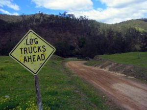
This road is passable even for two wheel drive – but some sections are narrow, poorly aligned and corrugated. A large water-filled dip has developed in the tunnel which could present problems but we presume someone is going to attend to that eventually. The tunnel is also not suitable for trucks or caravans. Leave with a full tank of fuel – there is nowhere to buy petrol.